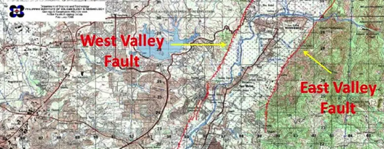
The Philippine Institute of Volcanology and Seismology (PHIVOLCS) released the Valley Fault System Atlas (VFS) which is a collection of thorough large-scale maps that demonstrates the areas that are in close proximity to an earthquake fault.
The VFS is composed of two segments:

West Valley Fault – running through Bulacan, Rizal, Metro Manila, Cavite, and Laguna.
PHIVOLCS has beforehand warned about probable impending activity from the West Valley Fault.
“We don’t usually use the word ripe because the fact would indicate that the West Valley Fault can move in our lifetime simply because the last earthquake that happened from this fault, most likely the 1658 earthquake 357 years ago, and the interval of movement of the fault is roughly between 400-600 years. So that’s very close,” said Director Renato Solidum, Director of PHIVOCS.
The magnitude 7.8 earthquake that hit Nepal last month might be the same magnitude that the West Valley Fault could possibly generate, but according to research this could be a 7.2 magnitude; while the East Valley Fault could generate a magnitude 6.2 earthquake.
According to approximates based on previous studies conducted by PHIVOLCS in partnership with the Metro Manila Development Authority (MMDA), Japan International Cooperation Agency, and Geosciences Australia said that in case of a magnitude 7.2 earthquake from the West Valley the fault, a death toll cannot be avoided – 31,000 to 33,500 people could die. In this particular study, an estimated damage would cost around P1.8 to 2.3 trillion.
Here is the list of barangays traversed by the VFS Atlas:
WEST VALLEY FAULT | |
Quezon City Ø Bagong Silangan Ø Bagumbayan Ø Batasan Hills Ø Blue Ridge B Ø Libis Ø Matandang Balara Ø Pansol Ø White Plains Ø Ugong Norte Ø Loyola Heights Ø Pasong Putik Proper (Pasong Putik) Ø Payatas Muntinlupa City Ø Alabang Ø Bayanan Ø Buli Ø Cupang Ø Poblacion Ø Putatan Ø Sucat Ø Tunasan Pasig City Ø Bagong Ilog Ø Ugong | Taguig City Ø Bagumbayan Ø Bagong Tanyag Ø Upper Bicutan Ø Central Bicutan Ø Lower Bicutan Ø Maharlika Village Ø Pinagsama Ø North Signal Village Ø Central Signal Village Ø South Signal Village Ø Ususan Ø South Daang Hari Marikina City Ø Barangka Ø Industrial Valley Ø Malanday Ø Tumana Makati City Ø East Rembo Ø Pembo Ø Rizal Ø Combo |
Outside Metro Manila | |
Bulacan Ø San Jose Del Monte City
Ø Norzagaray
Ø Doña Remedios Trinidad
Cavite Ø Gen. Mariano Alvarez o San Jose Ø Carmona o Bancal o Cabilang Baybay o Lantic o Mabuhay Ø Silang o Carmen o Inchican | Laguna Ø San Pedro
Ø Biñan o Biñan (Poblacion) o Malamig o San Francisco (Halang) Ø Sta. Rosa o Sto Domingo Ø Cabuyao o Casile Ø Calamba o Canlubang |
EAST VALLEY FAULT |
Rizal Ø San Mateo
Ø Rodriguez (Montalban)
|
high-magnitude earthquakes. This is not
a joke anymore, a series of calamities have been hitting our country and it is
mother nature’s way of showing us that she is real. The question and action there would be how we
are going to deal with it.
Manila hills subdivision po ba kasama?
Please share to me the list of Barangays near earyhquake faultline in Davao Oriental. Thanks po
Please send me the hazard map of municipality of Mati City, Lupon and Baganga Davao Oriental. Thanks po
Please update po kmi sa barangGay halang naic cavite near San roque 😢😢😢
Please do furnish us the fault line covering the Leyte Province
I want to know also the possible status here in compostela valley province….
Please do furnish us the fault line covering cavite city
kasama po ba ang San Juan floodway Taytay Rizal?
Please furnish us the list of brgys in Amulung, Cagayan which have fault lines! Thank you so much!
North Luzon po?(Pangasinan/Benguet)pls
PLS SOME OF TOWNS , BARANGAYS OF NEGROS OCCIDENTAL DIN PO. THANKS.
Please let us know the faultlines of samar and leyte. Can you show us thru our map? Thank you. At least we will be aware of this.
bago po ba eto year 2020?
Pashare naman po ng Map ng Fault line sa San Jose Del Monte Bulacan (San Isidro, Ciudad Real & San Roque). Malayo po ba sa Kelsey Hills ‘yun? Thanks po
Paano ba mamalalaman exact location ng faultline ?, Kasi if ever na mangyari yon syempre mag eevacuate mga Tao , Pano nila nalalaman Kung safe Yung Lugar na pupuntahan nila? Baka lumilikas Sila tas di nila Alam mas dangerous Yung Lugar nayun Kasi andon Yun faultline.
im from district 5 port area manila po update lng po,wla po kc ako nklagay? and sa bandang tondo manila po?
Pls update pasay malibay please branggy 161
Kasama ba Eastwind Homes, Bgy. San Isidro, Rodriguez, Rizal?
Tanauan Batangas ang Pasay -SMDC condo close to MOA is this close to fault line
Just wondering about the date of this warning or alert?
Kasama po ba ang Antipolo City sa Rizal sa East Valley faultline ? Salamat po !