In a recent post, we mentioned that PHIVOLCS is going to introduce new programs for the safety of Filipinos. Now, the HazardHunter Georisk is available and you can access it here -> https://hazardhunter.georisk.gov.ph/. But how can people use it?
This will be an extensive guide on how you can use the HazardHunter PH program. It is web based so you can access it if you have an Internet browser.
Read: PHIVOLCS Will Introduce 4 Disaster Reduction Apps
What is the HazardHunterPH?
The HazardHunter PH is a utility tool that is made by the PHIVOLCS together with the DOST and DOST-PAGASA for information to the citizens.
This tool can be used to come up with indicative hazard assessment reports on the specific location of a certain user. It can be used as a reference for those who are ought to purchase properties; land developers; stakeholders; and planners to be aware of the natural hazards of a specific location.
Read: Nationwide Dengue Alert by the DOH
Disclaimer form the HazardHunter PH: All information used for the calculation of hazard assessment results are based on the most recent updates provided by the corresponding mandated government agencies through GeoRiskPH. To know more about other archived data or more detailed information about the hazards, please contact DOST-PHIVOLCS for seismic and volcanic hazards, and MGB and DOST-PAGASA for hydrometeorological/climatological hazards.
How do you use the HazardHunter PH program?
Firstly, the main GeoRisk homepage will display the following main categories:

- How to Use
- Info
- Legend
The three (3) categories are quite self-explanatory, so you just need to click on it if you have any questions on how you can use the tool, information about the tool, and the Legend of the map that is currently before you.
Read: St. Luke’s Medical Center Offers a Comprehensive Insomnia Management Program
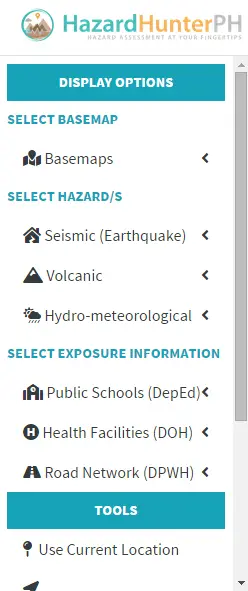
At the top left part of the webpage, there is a three (3) horizontal line menu button. Clicking on it will expose the following options:
Upon opening the website, you will be shown on the map of the Philippines. Of course, you would have to zoom in on the location of your choice. Double click on the map or tap it to choose the specific location.
Read: Five Vinegar Brands With Synthetic Acid Named by the FDA
After doing so, an initial hazard assessment will be displayed on the screen. If you want a detailed explanation and recommendation, you can hit on the View Report with Recommendations button which is available on the same area.
For you to see whatever we’re talking about, here is an image we have taken for example.
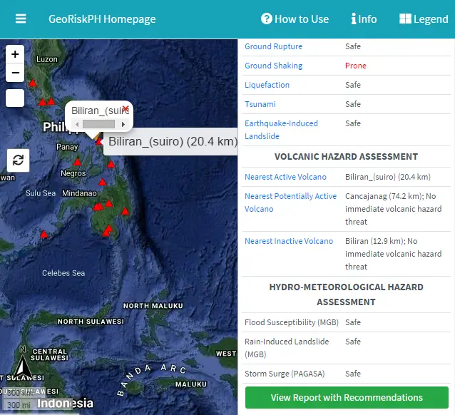
In the image, you will see that there are a lot of factors to consider. And as for Ground Shaking, the area we have selected is Prone to it. Others like Liquefaction, Tsunamis, and Ground Ruptures, it’s safe.
The green button at the bottom of that category is the button where it will redirect you to the detailed version of this summary.
So the website is actually very useful in letting people know about a certain area’s danger in terms of natural disasters. The website will provide a clear indication on whether a physical location is prone, susceptible, and safe from different disasters.
Read: PH Government Processing Proposed 22 Manila Bay Reclamation Projects
Although some areas are still being updated, the Department of Science and Technology (DOST) along with the Philippine Institute of Volcanology and Seismology (PHIVOLCS), is on the move in checking on the status of each and every location that can be seen on the map of the Philippines.
Do you need help in using the program? Are you one of the people who would be benefiting on the HazardHunter PH program? Do you know someone who would?
Well, here it is! The HazardHunter PH is now available for the use of the public and this is to give relevant information on a certain location’s status in terms of natural disasters. With this program, you can now be sure that the area you will be in is safe from any type of natural danger!